 |
| Picture taken form the post of Mon Dysangco |
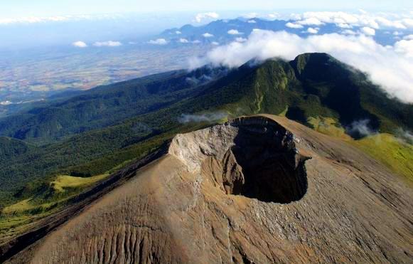
Mt. Kanlaon, the highest peak in the Visayas region, the largest active volcano in the country, located in the mountain ranges of Negros Oriental. September 23 to 25, 2011, I conquered the mountain for the 3rd time, via Wasay Guintubdan trail, a 3 day traverse climb from the town of Murcia to the city of La Carlota. My second time on this trail after ten years. At this time I am with Smart Mountaineering group, a climb that has been planned early part of this year. I got invited by some of my good friends who are part of the team, without second thought I said yes despite the possibility of just being the only guest on this climb.
 |
| At the airport, thanks Mondy for the picture |
True enough, I was the only climber not from the same mountaineering group. They invited me to join them for the very reason that I've been to the same trail before but truly for it was a climb for a long time already, I truly cannot remember all details about it anymore, all that I can remember is that this trail is a scenic one, a variety of several lakes and lagoons, water falls, thick forest, different flora and fauna along the way and a more challenging trail.
 |
| SMC with it's official service.... |
Majority of the group left Manila together on an early flight Friday via Air Philippines, it was already a cloudy day. When we arrived Bacolod Airport it was already raining. We waited for one of our team mate before we left the airport for Pala Pala for a sumptuous breakfast. The rain started to pour heavily while we are waiting for our food. After a heavy breakfast the team proceed to SM Hypermart to buy the remaining supplies for the climb. The rain continued until we transferred to SM hoping that we can fix our pack on the covered parking area while waiting for the two remaining members of the team who are in another flight later than we had. We waited for more than an hour, when they arrived we traveled for 45 minutes to the jump off of our climb, at the main entrance of Mambukal Resort in Murcia.
 |
| The team at Wasay jump off |
Luckily on our way to Murcia, the rain stopped but the weather is still gloomy, after 45 minutes of jeepney ride we unloaded our packs, met our guide and eat an early lunch before the start of the trek. It's best to have our lunch while in the community area, it's almost lunch time anyway, so despite our not so hungry yet from a heavy breakfast the team decided to just eat our mid meal, to avoid eating along the trail. After final fixing our pack, say a short prayer and physical stretching at around 12:15pm off we start the trek. We had two guides one in front and one as the sweeper of the team. I followed right after the lead guide.
 |
| climbers for wasay guintibdan trail - register here |
The trail started on an uphill cemented steps on the right side of the main entrance outside the resort. It passes through several community on the side of a fenced roaster farm for cock fighting. After several minutes is an open trail, good thing the sun shine a bit, we feel it's presence despite the muddy and slippery trail. After several minutes it passes through a rough road which leads to the house where we need to register as climbers of Wasay Trail. We followed again the road and a left uphill turn to the thick mahogany trees, tall enough to keep the trail shaded from the sun. After several minutes bushes becomes thicker until big leaves of ferns are now visible on the trail. This also marks the start of our constant look out for lematik (leeches). Some parts of this trail is expected to have leeches but because it has been raining the past few days, the appearance of leeches come earlier than expected. After several minutes, we come to a rough road again used by the PNOC.
 |
| At PNOC rd while waiting for the team |
This is just as passage to another uphill turn towards the forest. This also starts our unending uphill trail passing through trees sometimes under or over it. There are times that I hit my head of a tree under estimating how low it is. This also starts my trekking alone most of the time. Being with the lead and following right next to the guide, I had to cope with is pace, but of course, this is his playground, I really cannot follow him that close. So he walk faster, disappear in my sight then at some point will wait for me, once I am visible to him he will start trekking again. Such style of trail management is being observed from day one up to the end of our trek. There was a very minimal rest stops and trail food stops for me. The person next to me is also behind me for several minutes, sometimes almost an hour.
 |
| Emergency Campsite, Day 1 |
Due to delayed itinerary, our guide decided to camp on emergency campsite for day one, right after the river, we arrive 4:00pm, still has light and still early but because the next campsite is another 2 to 3 hour trek, we decided to have our day 1 camp area on this side of the mountain, not an ideal campsite for the terrain is sloping but that's the best that we can have, besides it's just right next to the river, our water source. Since I carry my entire tent, I choose a site and pitched right away, after several minutes it rained.
 |
| mossy trail |
Thank God I already finish pitching my tent. the rain did not stop, it continued pouring heavily, as in literally it's like a water pouring in a gutter of a house. And it did not stop, thank goodness I brought my new tent, it is moist on the floor but at least we are dry with the help of the inner ground sheet. It's time for us to cook dinner but because it is still raining, I feel like not going out of my tent. I help the kitchen by doing some slicing of the chicken meat inside my tent. What made this campsite more challenging there are leeches around so every time my tent mates get inside, I made sure that they do not have any leech with them. It is already a cold campsite but I thank god i brought enough cold weather gear that keeps me dry and warm the entire night. What's just bothering me is my congested nose on the wee hours of the night.
 |
| at the river |
We woke up on the second day with no more rain at all. I got to start cooking, we are still the one assigned to cook for breakfast and pack lunch. And take note there is still leeches even on the kitchen, it is really a challenge to just even pee or poo on this site. Our original target of leaving the campsite by 7 am becomes a reality by 9am. My pack now is more heavier, my tent is all but soaked in the water with minor mud. As usual I trek right next to the lead guide, trail at this time is more challenging with more uphill ascends and some downhill slopes. The trail is now more slippery than the other day probably because of the rain the night before. Now trekking becomes more challenging, with the terrain I have to double my pace to cope up with Kuya Bakla at the same time check myself from limatik bites.
 |
| The big tree |
After several minutes from the big tree it started to drizzle, I decided to stop and put on my rain coat, I wanted to be at least warm and dry on this windy cold trek. Eleven a.m. the guide and myself arrive at the Junction, our suppose to be campsite for day 1, which turns out to be our lunch area of day 2. As we stayed longer waiting for the next next person to arrive it becomes colder, we are trying to find heat in a ray of light from the sun the perched through the thick leaves of the tall trees around the campsite. It was also in this rest stop that I noticed one limatik bite in my left hip, damn, I have one limatik bite. I've been very careful on the trail but still I got one bite already.
 |
| At Junction Campsite, our lunch area for D2 |
After an hour the team arrives, we cook soup and boil water for the sachet of goldilocks food. This is something I do not do in most of my climbs, eating warm food for lunch. Going to the next campsite will be another 6 more hours from the Junction, that will be a long trek though the guide told me, with our pace that will be another 4 hours. After two hours we proceed with the trek, passing by hardin sang balo, a place of mossy and gray branched trees on a swamp area, a nice place to drop by when using this trail, it is worth the 15 minute spare of your time.
 |
| Harden sang Balo |
After several hours of trek, it was already cold, the wind is just blowing furiously and due to the drizzle, I am already wet, though I tried my very best not to wet my shoes. Upon reaching the monkey trail, an 80degree ascend I asked the guide for a 5 minute break to replenish food, stayed for a while then resume our trek. It's all uphill now with some ridging on each slopes until we finally go for a descend, I know we are almost to the campsite and besides it's getting late already. Quarter to five the guide and myself arrive the campsite but the water is high, and there is no good place to pitch the tent. I can't even have my big tent pitched well. I give up looking for a big space and settle for what has been hacked for me. Not the best but at least I was able to set it up. The kitchen is not a good place either, it's windy and very cold. And since our group is not assigned to do the cooking I resign to my tent for a while with my tentmates Jing and Arvin.
 |
| Samoc Campsite, true to it's name, samok kaayo |
Day 3 is colder, no rain but because of the mist from the wind that blows in all directions from the lake, our tent fly is wet and drizzle can be felt. Since I cannot sleep anymore I decided to wake up but no one is out, our target of getting started by 7am is not a reality again at this time. The cook at this time did not come out yet, so I just roam around the camp area despite it's cold condition. It was a double time breakcamp for us, I feel like we are slower at packing our things at this time and being the one bringing the tent, I cannot start packing without my tent yet. 8:30 we left to target the Pagatpat Campsite.
 |
| AT PMS Lagoon |
Reaching the PMS campsite, I remember this area 10 years ago, and it's all the way to the gully that pass by some water falls. A long ascend first before it goes to the ridge before it goes down to the side of the Margaha Valley, now the guide is sure that there would be no view at the crater. The best is to go down for it seems like the weather will not improve. The group decided to go to the saddle first and up to the rock, the farthest that the group reached, it was really foggy and windy. There is just no way that we can reach the crater.
 |
| At Pagatpat Campsite taking lunch on D3 |
After an hour we come back to Pagatpat, cook our food for lunch until before we are going to eat it rained heavily. We are now soaked in water making it more cold to stay. After eating we left, descend to the end of the trail. It was a literally trail running for us with a heavy load, especially on the fern area where leeches are waiting for human creatures like us. We arrived Guitubdan still on day time and spared by the heavy rain.
This is once again a challenging trek for me, with such a long terrain with many uphill slopes on a cold weather carrying a heavy load is again my deposit to to my bank account of endurance. I thank the Smart Mountaineering Club for wholeheartedly accepting me on this climb despite that most of them is my first time to be with . Despite the no view, and the group did not make it to the summit, it has been a successful climb and all were able to come down safe and whole.
 |
| Group pic at the rock, the furthest the grp can go |
Total Expenses for this trip including plane fare: PhP4,620.00
Rented a jeep to meet at the airport going to Mambukal
Eat breakfast at Pala pala
Stayed at K-mas Hostel
Visited the Ruins
Eat at floating restaurant in Bilaring
The group's itinerary based on actual climb by the lead pack
September 23, Day 1
12:15PM start of trek at Mambukal Resort
1:00PM register at Nipa Hut, first water source
2:00PM PNOC road
3:45PM River and emergency campsite, our campsite for day 1
September 24, Day 2
9:00AM - start of trek
10:00AM River
10:15AM Giant Tree
11:00AM Junction Campsite
2:00PM Start of trek
2:15PM Harden sang Balo
4:45PM Samoc Lagoon, our second campsite
September 25, Day 3
8:30AM Start of trek
10:30AM Pagatpat Campsite
11:00SAM Saddle, picture taking at the rock
2:00PM Start of trek
3:00PM Camp 2
3:15PM Camp 1
5:00PM Guintubdan, end of trek


Very nice moangat riyan Madamme tuwing Holy week times coz di xyadu maulan.. :)
ReplyDelete