Of the several races that I joined especially that of a trail run, I always thought it could have been nice if I could have a chance to see and recon the route of the race. I guess that lessens the so many unknown factors that lingers my mind and at least I can anticipate on what I need to prepare both physically and mentally. For this particular race, my mountaineer friends and some runners too from Baguio invited me to join them on several reconnaissance on the route of the race. Such a good idea, I will get a chance to be with them and have a first experience of the trail as well.
 This recon has been on several phases on my several trips to Baguio. Though I intend to run and see all of the difficult parts of the entire route, I was not able to do it. But at least I was able to do some difficult parts of the trail. And as much as I wanted to experience doing the run at night, I was not able to do it as well but instead I was able to experience a harsh condition on the trail, having to experience rain and wind at the highest point and the most exposed part of the route.
 On most of our recon, the entry points are those that are accessible by vehicle, by a public transportation and a private car. On the last phase of my recon, on some part of it, it is already by car just to have an idea of how the trail looks like. I hope this will give others who are also doing the 100 kilometer distance on this race a picture of how most part of the trail looks like.
PHASE I (Ampucao to Camp 1)
The group left Baguio City riding a public jeepney and take off at Sitio Batuang, Ampucao, Itogon. We take a short trek on the road then turn right to an uphill rough road through a steel and wooden gate. That starts the Phase 1 of our recon.
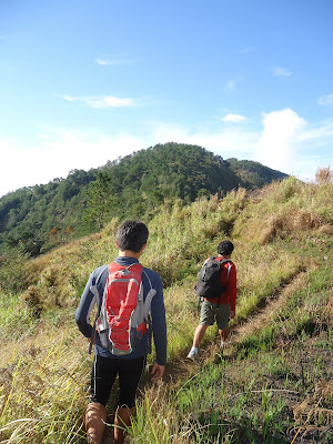 It's a trail hitting the several minor peaks of Ampucao traversing from an open trail with variety of tall and not so tall grass and bushes. Then the trail leads to pine tree covered areas, some of it traversing to the top most slope of the hill, then making a minor downhill before it goes to another uphill approach until it reaches to the next hill. After covering several kilometers for several hours we reach an open ridge, seeing one side the Itogon and the other side of Tuba. The rolling uphill down hill slope of this area is not an easy one, all that I can say, but the scenery is just simply rewarding, simply breathtaking, just like a mini Pulag place.
 The open ridge gives a scenic view of mountain slopes as far as your eyes can see. But it also has cliffs and ravens on some parts which runners should be very careful from falling. This trail is being used by the locals making several trails, one needs to be mindful of where it will lead, you might end up on a wrong side and not to the community where you are heading. There are several fence which one has to go over in order to reach to the next part of the trail. There are also herd of cows on the trail, one has just to shoo them away from the trail, they are harmless and nothing to be afraid of. From the part where we started the trek, at this point it is already 7 kilometers of rolling terrain, beautiful view and nice trail for running.
 Upon reaching the area where one can see the Phelix Mining open pit and spillway, the group enter the trail on the right which will now lead inside the forest. This turn should not be missed otherwise runners will lead to a different community if a wrong turn will be made. This trail used to be a hunters trail, that's what Kuya Mimis said, which has not been used for sometime now I guess, it seems like this has just been cleaned and re-opened just for the race. It's a downhill single track trail which runners will really need to pass one at a time in some parts. I guess there will be traffic on these areas if more runners will come together.
 The forest is surrounded by tall slim trees with branches wrapped by green moss, not pine trees as compared to the trees that we encounter from the start of our trek early on. This is a 3 kilometer rolling slope inside the forest passing one empty house then goes to an open trail again away from the forest now leading the tall bushes until it will reach the very first house with potable water, this can be a water refilling station. Because inside the forest line is dump, wet and cold, this place is a no exemption of the blood sucking leeches too. Though it was not raining that day, one of our companion has one leech bite. After that house is another rolling trail now wider, more clear and clean from bushes, grass and dried leaves. Until it will reach to a vegetable plantation with a house beside it.
 This will now lead to a combination of rough road, paved road, less graveled road of Ligay in Tuba Benguet. At first it will be a combination of minor downhill, minor uphill passing by houses and community. Just be careful though, it is common in Benguet that almost each house has a pet dog and some of them are not tied up, which they will really run after you when you will pass by. This place is not an exception of it. As much as possible I take the lead on this part, taking advantage of running but every time I encounter dogs barking, I just slow down and wait for my companions. Another thing that one should take note is that there are road intersections that leads to several communities as well. Just be mindful of the trail signs so as not to be off trail. Despite the never ending killer downhill, I really enjoy this part of the trail, one more thing I noticed as early as that of the vegetable plantation area, there are lots of different colored butterflies, and as we start our descend on the rough road aside from butterflies, there are dragonflies too. I just enjoy running with the companion of butterflies and dragonflies around and wish I won't encounter snake on this trail which I am thankful I did not.
 Take note of the El Dorado Cooperative Store, this is the best store to replenish, load up, eat and drink before heading again. Because after the uphill paved road on the right side of Ligay Elementary School will already be a rough road of downhill descend all they way. It will never be an ending downhill of dirt road, not even so clean from bushes and at some point no community at all. After taking some turn all you wish is a bonus of a relax slope but there is none at all, it's another steep downhill and downhill slope again and again. Really, this I call a killer downhill road with a distance of 11.8 kilometers.
 After several hours, tired and hungry, all I can wish for is the end of this downhill road. Runners very sign of almost done with this part is the sound of the passing vehicles until one will end up at the main road at Camp 1, Kenon, Benguet. The Bridal Veil Falls is now visible across the road. A rest and load up again at the community is a good thing to do before hitting the next 5 kilometer ascend to twin peak. But we did not do anymore the Twin Peak ascend. Our Phase 1 recon ends at the Camp 1 community covering 28 kilometer in 8 hours. In the actual route this part will already be 50 kilometers, hopefully reaching this area before 3:00pm, that would be too long already.
Pictures: Ampukao to Bridal Veil Falls
PHASE II (Eco Trail to Secret Trail)
 This is just a relax run for us, this is in our common favorite playground, inside Camp John Hay. Traversing the rolling slope inside the pine forest we just enjoy the trail, at this time making it more of a training mode rather than a walk in the park mode of yesterday's recon. So we gain more mileage in shorter time. It was my first time though at secret trail which will also be part of the first 15 kilometer of the race before it will lead outside to the mountain slopes. The secret trail also has a killer uphill trail that leads to a familiar route. The trail on this part is well maintained, wide enough for running, and clean and is even used for mountain bikers. It's inside the pine forest so it is not hot.
Pictures: Eco Trail and Beyond
Just before lunch the group decided to call it a day, just before the heavy down pour of the rain. There it goes my two day recon. When will be the next and what part of the loop will it be, I still do not know.
Note to self so far:
1. Long tights is more appropriate for there are parts of the trail with tall bushes and there are leeches too.
2. Arm sleeves to cover both arms when it gets colder due to the wind and weather and when it gets hotter especially on the open and exposed part of the trail, one can just roll it down, more flexible than long sleeves (just a thought).
3. Bring sufficient trail food for community are far from the trail.
4. Take it slowly on the 11.8 kilometer killer downhill part.
5. Bring jacket, gloves and bonnet, it gets very cold on the evening on the exposed part of the trail.
6. A pair of trekking pole would be a very big help on the ascend part.
7. Pray harder that it will not rain on the day of the event.
 PHASE III (Camp 1 to Twin Peaks to Andolor to Cabuyao Relay Station)
The start of this recon is from Camp 1, Kenon, Benguet, this is the 50 kilometer mark of the TNF race. On the actual race, runners should reach this point not later than 5:00PM or exactly 14 hours from gun start. Passing the big river through the hanging bridge, at the end of it we turn left, it is the start of a long ascend. It's a single track trail shaded from the trees on the side. The trail switched back on the side of the mountain but it has flatlands that one can recover. On the higher slopes are few houses with farmlands, trail now open and expose to the direct heat of the sun. One can now see the mountain ranges of the different parts of the Cordelliras. As the trail goes further ascend, it will lead to an open rough road, still going further upward.
 But since this is the second leg of the race proper, runners will most likely pass this area late mornng for the elite runners or early or late afternoon or early evening. This is a 5 kilometer stretch from a single track trail to a rough road, there are few houses along the trail and road but mostly nobody is around the time we do the run. Until finally we reach a big house that has a sarisari store. It is good stop to replenish food and hydrate at this house after that long stretch. This will continue on to a rough road that leads to the Barangay Hall of Tabaan Sur, Tuba, Benguet.
 After the rough road with several houses of the local community, the trail will now lead to another uphill rough road that slowly lead to a single trail. This now is the start of a more than 10 kilometer of uphill single track trail mostly under the shade of the pine forest. There are two parts on this leg, on two area inside the lush forest that have blood sucking leeches again. Just be prepared for this. There is one long stretch of direct ascend comparable to that of Akiki trail in Mt. Pulag. It's a never ending ascend with trail switched back on the slope of the mountain. Looking at the race map, this part of the race is a big possiblity that it is already dark or late afternoon for othrs that are really fast, there are minor trails that might lead to a different track, so be very mindful of the race signages on this part. But at least after a long uphill stretch is flatland again that can serve as a rest stop if needed or a relax trek after that long uphill ascend. A minor descend then slowly followed the side contour of the mountain further moves towards the ridge will soon lead to a minor downhill which will lead to a rough road with minor ascend again. until it will reach the junction which will a trail leading to the summit of Mt. Sto. Tomas. This part is still a gradula ascend. This trail is the back door approach to the highest point of this race, Mt. Sto Tomas with an elevation of 2,250MASL.
 After that ascend will be a combination of rough with gravel and paved road that will now lead to a much lower elevation of Mt. Cabuyao. The distance is less than 4 kilometers but because it is downhill with gravel, it's just not so friendly to the knees when one tries to run faster. This part too will start the appearance of a local community. It has several houses on the side of the road some with sari sari store in the evnt that runners want to replenish supply, hopefully if they are still open and awake by the time runners will reach this point. This will lead to a trail again towards the Relay Tower in Mt. Cabuyao. A single downhill trail at the back of the tower will now lead to the remaining 25 kilometer distance of the race. Unfortunately I do not have the time to do that part anymore.
Pictures of Phase III Recon: Camp 1 to Cabuyao through Andolor
PHASE IV (PMA, Loakan Road, Airport, Happy Hallow)
 I am lucky I was able to run a portion of the trail inside PMA. This is comparable to that of the Yellow Trail, the trail inside John Hay, the first part of this race. It is a rolling trail under the pine forest. The rest, I really haven't got a chance to do it by foot but rather by car on our way back to the city. This is almost all a gradual uphill road, if race route will be using the road.
The mountain slope on this picture is the view of Mt. Sto. Tomas and Mt. Cabuyao as seen inside PMA. This is the slope that runners will go down coming from the back part of that mountain entering the trail at the back of the radar as seen on the left part of this picture on the peak of the mountain. This is going to be an almost 8 kilometer descend before reaching to where this picture is taken. And most definitely most runners will be traversing this part of the trail mid noon to late afternoon for elite runners and early evening or probably early dawn for majority of the runners. There will be some exposed parts that will be too windy and cold especially on the wee hours of the night.
Upon the release of the updated and final route map for the 100 kilometer distance, I made my own notes, as my personal guide. As part of my mind setting I study the map, which part and at what distance will it be, and what time I should more or less reach that area.
That ends my recon of the TNF 2012 route. Happy trail running everyone and see you all on the trail. This is going to be a race full of adventure, fun, wild and memorable. Excited and looking forward the race day....
 |
| A more updated race map |


PHASE I (Ampucao to Camp 1)
The group left Baguio City riding a public jeepney and take off at Sitio Batuang, Ampucao, Itogon. We take a short trek on the road then turn right to an uphill rough road through a steel and wooden gate. That starts the Phase 1 of our recon.


Pictures: Ampukao to Bridal Veil Falls
PHASE II (Eco Trail to Secret Trail)

Pictures: Eco Trail and Beyond
 |
| From the photo album of Mark |
Note to self so far:
1. Long tights is more appropriate for there are parts of the trail with tall bushes and there are leeches too.
2. Arm sleeves to cover both arms when it gets colder due to the wind and weather and when it gets hotter especially on the open and exposed part of the trail, one can just roll it down, more flexible than long sleeves (just a thought).
3. Bring sufficient trail food for community are far from the trail.
4. Take it slowly on the 11.8 kilometer killer downhill part.
5. Bring jacket, gloves and bonnet, it gets very cold on the evening on the exposed part of the trail.
6. A pair of trekking pole would be a very big help on the ascend part.
7. Pray harder that it will not rain on the day of the event.

The start of this recon is from Camp 1, Kenon, Benguet, this is the 50 kilometer mark of the TNF race. On the actual race, runners should reach this point not later than 5:00PM or exactly 14 hours from gun start. Passing the big river through the hanging bridge, at the end of it we turn left, it is the start of a long ascend. It's a single track trail shaded from the trees on the side. The trail switched back on the side of the mountain but it has flatlands that one can recover. On the higher slopes are few houses with farmlands, trail now open and expose to the direct heat of the sun. One can now see the mountain ranges of the different parts of the Cordelliras. As the trail goes further ascend, it will lead to an open rough road, still going further upward.


Pictures of Phase III Recon: Camp 1 to Cabuyao through Andolor
PHASE IV (PMA, Loakan Road, Airport, Happy Hallow)

The mountain slope on this picture is the view of Mt. Sto. Tomas and Mt. Cabuyao as seen inside PMA. This is the slope that runners will go down coming from the back part of that mountain entering the trail at the back of the radar as seen on the left part of this picture on the peak of the mountain. This is going to be an almost 8 kilometer descend before reaching to where this picture is taken. And most definitely most runners will be traversing this part of the trail mid noon to late afternoon for elite runners and early evening or probably early dawn for majority of the runners. There will be some exposed parts that will be too windy and cold especially on the wee hours of the night.
Upon the release of the updated and final route map for the 100 kilometer distance, I made my own notes, as my personal guide. As part of my mind setting I study the map, which part and at what distance will it be, and what time I should more or less reach that area.
| Time | From | To | Distance in KM | Total KM | Place |
| 3:00am | Start | AS1 | 7.4MK | 7.4KM | John Hay |
| AS1 | AS2 | 10.4KM | 17.8KM | Itogon | |
| AS2 | AS3 | 11.3KM | 29.1KM | Ampucao | |
| AS3 | AS4 | 11.8KM | 40.9KM | Mt. Poris | |
| 5:00pm | AS4 | AS5 | 12.5KM | 53.4KM | Camp 1 |
| AS5 | AS6 | 10.1KM | 63.5KM | Tabaan Sur | |
| 1:00am | AS6 | AS7 | 9KM | 72.5KM | Sto. Tomas |
| AS7 | AS8 | 2.9KM | 75.4KM | Mt. Cabuyao | |
| AS8 | AS9 | 7.6KM | 83.0KM | PMA | |
| AS9 | AS10 | 5.7KM | 88.7KM | Airport | |
| 9:00am | AS10 | Finish | 11.3KM | 100.0KM | John Hay |
That ends my recon of the TNF 2012 route. Happy trail running everyone and see you all on the trail. This is going to be a race full of adventure, fun, wild and memorable. Excited and looking forward the race day....
No comments:
Post a Comment